Tate holds the national collection of British art from 1500 and international art from 1900 (c.70,000 works in all). About one third of the collection has been indexed by Tate with information about locations, typically the site represented. For some works this information is quite specific but in many cases it is quite general, referring only to a city, region or major geographical feature. The Art Maps project aims to improve the quality of the geographical data relating to these works, with members of the public contributing information about the specifics of the images, viewpoints used or associated places. It also will allow people to record and share their memories and emotional or creative responses to the locations associated with the artworks in ways that will generate learning experiences and create new communities.
Over the course of 2012 the Art Maps project will develop one or more applications for use on smart phones that will allow people to relate artworks to the places and environments they encounter in daily life (a website will also allow desk-based users to view and annotate maps but the project will focus primarily upon the use of mobile technology). By looking at place in relation to artworks, they will become more familiar with both the location and the art, gaining insights into how artworks relate to or differ from the sites they represent, how sites have changed over time, and how sites have been represented and experienced by different artists. Importantly, the new software will enable audiences to explore ideas of location and environment, representation and memory, both on their own and collaboratively in groups (for example, families, friends and schools).
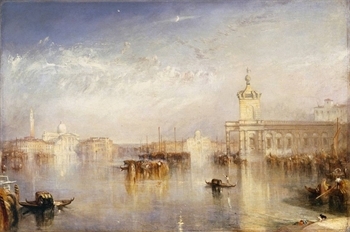
| J.M.W.Turner The Dogano, San Giorgio,Citella, from the Steps of the Europa exhibited 1842 |
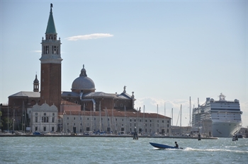
Passing San Giorgio, Venice, 2011.
Photo by Gabriella Giannachi. |
It is expected that the new app will enable members of the public to help Tate pinpoint the locations of particular images and identify the viewpoints used by artists through sending comments or uploading their own photographs or videos of the sites for publication on Tate’s website. The app will analyse users’ locations and display artworks that are associated with that location (typically because they represent it or were created there). With works that are not specifically ‘about’ a location (for example, abstract works or performances), Art Maps will offer audiences the possibility of annotating the works in relation to, for example, the site of a performance or the artist’s studio. Additionally, Art Maps will facilitate the creation of journeys through cities according to a particular artist’s work (J.M.W. Turner’s views of Venice, for example), a movement or a theme.
Through the creation of new software, the project aims to:
- develop ‘art maps’ for exploration by place through mobile devices and an associated website;
- invite and capture associative responses to place and space;
- test whether the new software will engage users in new ways with artworks in the collection, particularly the less well known ones;
- explore how mobile technologies can support individual and group learning beyond the gallery;
- develop protocols and processes around the publication of user content on Tate’s website;
- test how information about the locations of artworks in Tate’s collection may be crowdsourced;
- explore the value of crowdsourced information and associative contributions by the public;
- develop and offer (under open source) a mobile web interface as a tool that can then be used or repurposed by others.
Art Maps is developed by researchers at the University of Nottingham and University of Exeter with funding from Horizon, an RCUK-funded Research Institute for Digital Economy Research, in collaboration with Tate. Established in 2009, Horizon brings together researchers from a range of disciplines to investigate how digital technology can enhance the way we live, work and play. The prototype application will consist of an Art Map of Tate’s collection; future Art Maps may involve other collections.
Horizon Researchers Laura Carletti and Dominic Price win £10,000 for their Telling Tales of Engagment project Art Maps at The Digital Futures Conference 2012 in Aberdeen.
Partners: Tate
Telling Tales of Engagement
Art Maps – Telling Tales of Engagement aims to further ‘tell the story’ of the impact of the Art Maps research project to a
wider and differentiated audience.
Over the course of 2012 the Art Maps web and a mobile application were developed, allowing people to relate artworks to the places, sites and environments they encountered in daily life. Importantly, the new software enables audiences to explore ideas of site, place and location, environment, representation and memory, both on their own and collaboratively (for example, families, friends and schools). Art mapping, as audience engagement mechanism, was investigated through two workshops, held respectively in April and in October 2012 at Tate Britain in London. The preliminary results are promising suggest a value for a further dissemination of the project to a wider and differentiated audience.
To further ‘tell the story’ of Art Maps, in 2013/14, our objectives are:
1. Exploring the Art Maps applications as engagement tools for digital audiences;
2. Involving the public to create art trails, supported by the Art Maps applications;
3. Engaging the research community through interactive experiences, supported by the Art Maps applications.


